
Mondays are traditionally days of dread; the weekend is over and it’s back to the grind. I am currently off Sun/Mon, so my Mondays aren’t quite the same as most peoples. Still, it’s typically a day of rest…especially if I’ve taken a road trip recently, like yesterday’s drive to Missouri. However, I had yet another trip planned. Although today’s destination wasn’t quite as far away, it had more possibility than any other place I’d yet been in Oklahoma. Did it live up to my hopes? Let’s just say January 26th, 2015 is a day for the Rhys Martin History Book. But what’s a road trip without a few detours first?
 I woke early, once again hitting the road before the sun came up. I gassed up, coffee’d up, and headed north. The path was one I knew well: Highway 75 north to 20, over to Skiatook, and up Highway 11 to Pawhuska. It’s the road packed with the most memories for me, as I’ve written before. I thought about my grandparents and my father as I wound around those familiar curves, stopping briefly in Avant to get a few pictures of my favorite bridge as the sun rose. Once I got to Pawhuska, though, I kept going. My first stop was a ghost town on the Kansas/Oklahoma border named Elgin. I turned down a gravel road and listened to the familiar churn under my tires as I wound through the countryside.
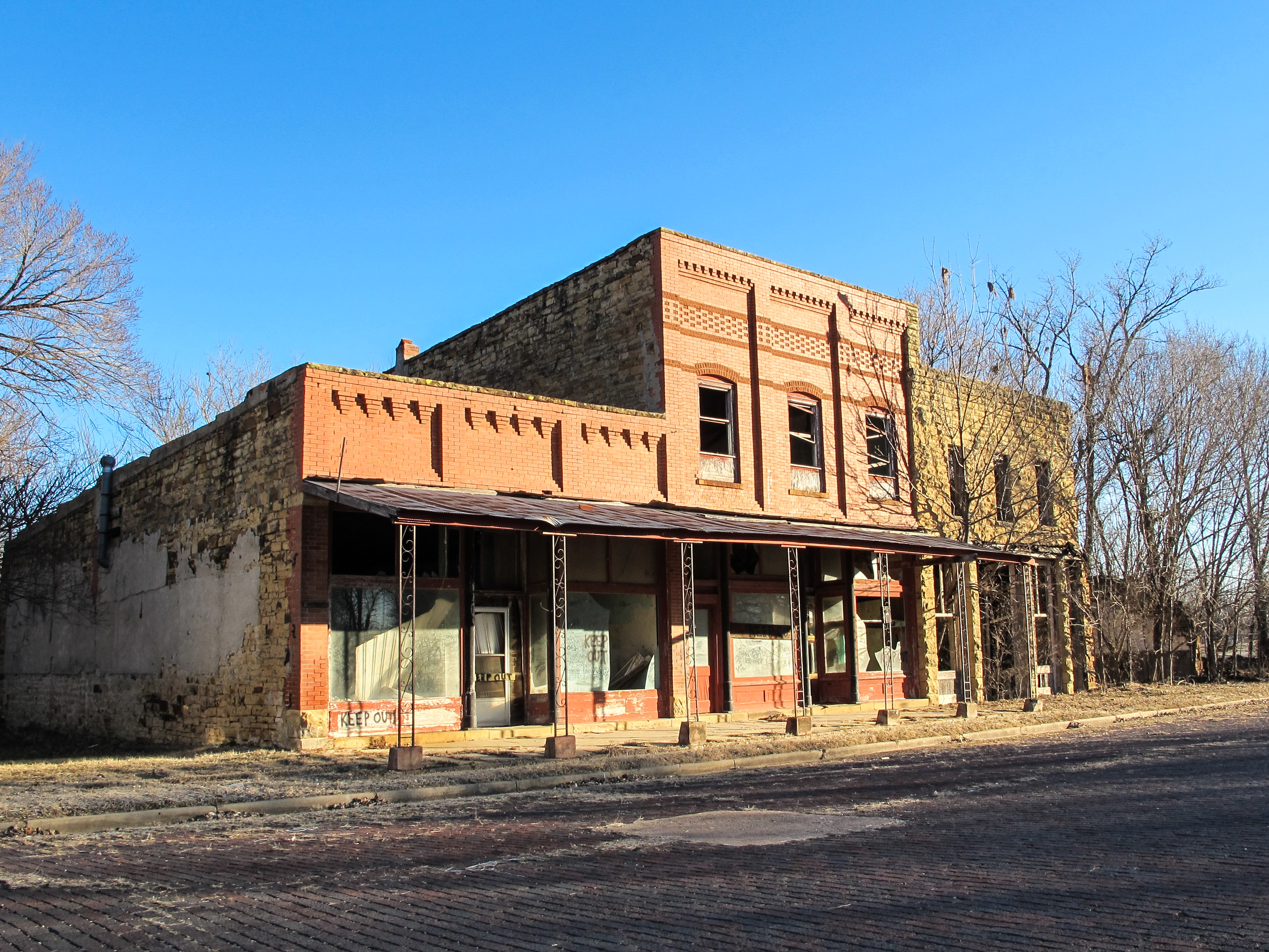
A lovely two-span metal truss bridge welcomed me to town. There were several wooden signs labeling Elgin “A Town Too Tough To Die”. Considering their post office closed on the Bicentennial, I’ll give ’em that. There was an amusing signpost not far from the bridge with mile markers to all sorts of destinations, and for a ghost town there were quite a few houses in decent shape. 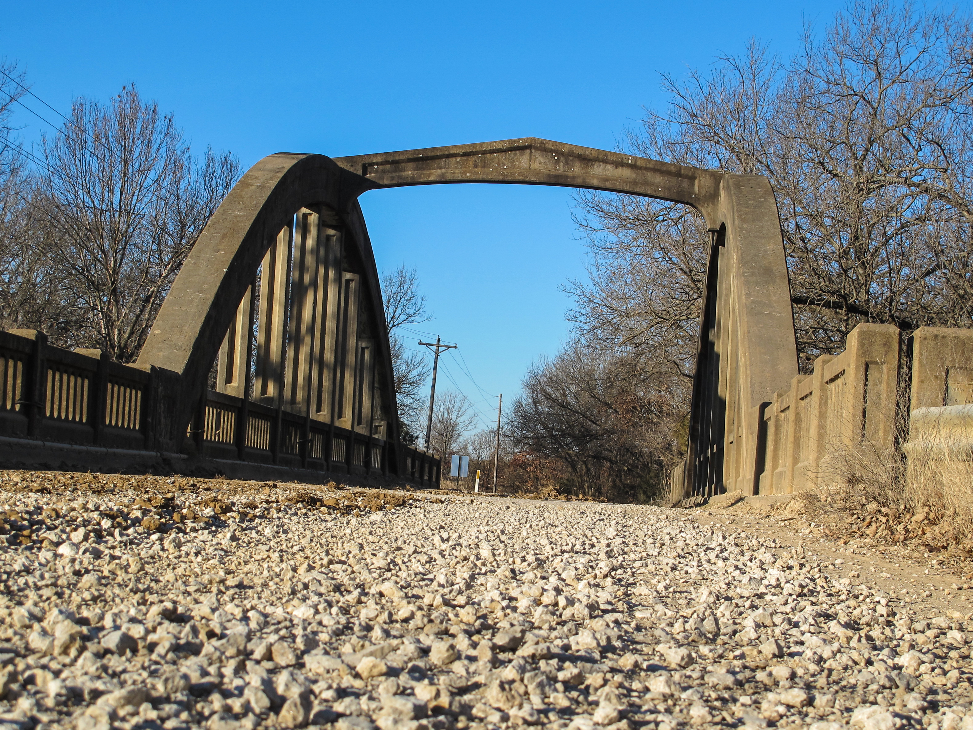 The downtown area had a small collection of buildings (all closed and in various states of collapse) and a brick road. You could tell where the railroad once was, too, after it had been paved over. It wasn’t too difficult to visualize a busier town, though I didn’t see a single soul during my visit. Before I moved on, I drove to the east edge of town and took some photos of a marsh arch bridge, which Kansas is full of and Oklahoma has only one. It was cool to visit a town that had both a concrete arch and a metal truss bridge, which is actually a rare sign in Kansas. It’s weird how something can be plentiful in one state, and pretty much non-existent in its neighbor.
Satisfied with this diversion, I drove west and crossed back into Oklahoma just north of Newkirk, where I pulled up to the locked gate of the Chilocco Indian Agricultural School. I was met by a lovely woman named Crystal that worked for the Kaw Nation; my cousin had arranged our acquaintance. The school is not open to the public. It’s used for law enforcement training some these days; it hasn’t been used as a school since it shut down in June of 1980. I had a bit of a moment when I realized it had been closed since before I was born. I wasn’t really sure what to expect as we drove down the road to the main grounds…but when the trees cleared and I saw the yellow limestone buildings for the first time, my jaw hung open in surprise.

It was huge. There were over 20 buildings scattered across the campus, which spanned nearly 300 acres. It opened in 1884 to help integrate American Indians into the mainstream and served as a boarding school for over 18,000 students in nearly 100 years. In the 1930s, there were widespread reforms that worked to balance vocational teaching with more academic studies, though accounts from students indicate this wasn’t terribly effective. Enrollment was highest in the 1950s (about 1,300 students) but declined as other public school options became available. Additionally, there was a sit-in demonstration by the National Indian Youth Council in 1972 due to alleged abuses. By the time it closed, there were only about 100 students attending. The school was then gifted to five local tribes: the Kaw, Otoe-Missouria, Pawnee, Ponca, Tonkawa, and Cherokee.
 Severe weather and years of atrophy had done some pretty serious damage to a few of the buildings, especially the main hall. The roof had completely collapsed on one side thanks to an earthquake a few years ago. A lot of the wooden houses were falling down and there was plentiful ‘KEEP OUT’ signage and danger tape about. There were three restored buildings scattered about, used for the aforementioned law enforcement training, but everything else was in disrepair. I was told to be careful and use good judgement, but that the grounds were mine to explore. If a door was open, I was welcome to enter. I set off with glee.
 I walked in and around a few of the dormitories, the dining hall, vocational shops, garages, and what was left of the residential area. One of the buildings, called Wheeler Hall, was much newer (I learned it was the boys’ hall in the 1970s) but most had been around a long time. I found a little gas station, a fire station (complete with restored fire truck), and the gym. Crystal had told me the gym was pretty cool inside if it was still open, but the front door was locked tight. I wandered around the side and discovered an open doorway…so I went in. Words cannot accurately describe the feeling of being in such a place. The paint was peeling off of the walls, the ceiling tiles had almost all fallen, and the wooden gym floor was coming up in many places. Funnily enough, the old Indian mascot was still visible on the wood and walls of the main gymnasium. There was a huge swimming pool (empty, thank goodness) and an old shower area in the back. It was creepy, but cool.
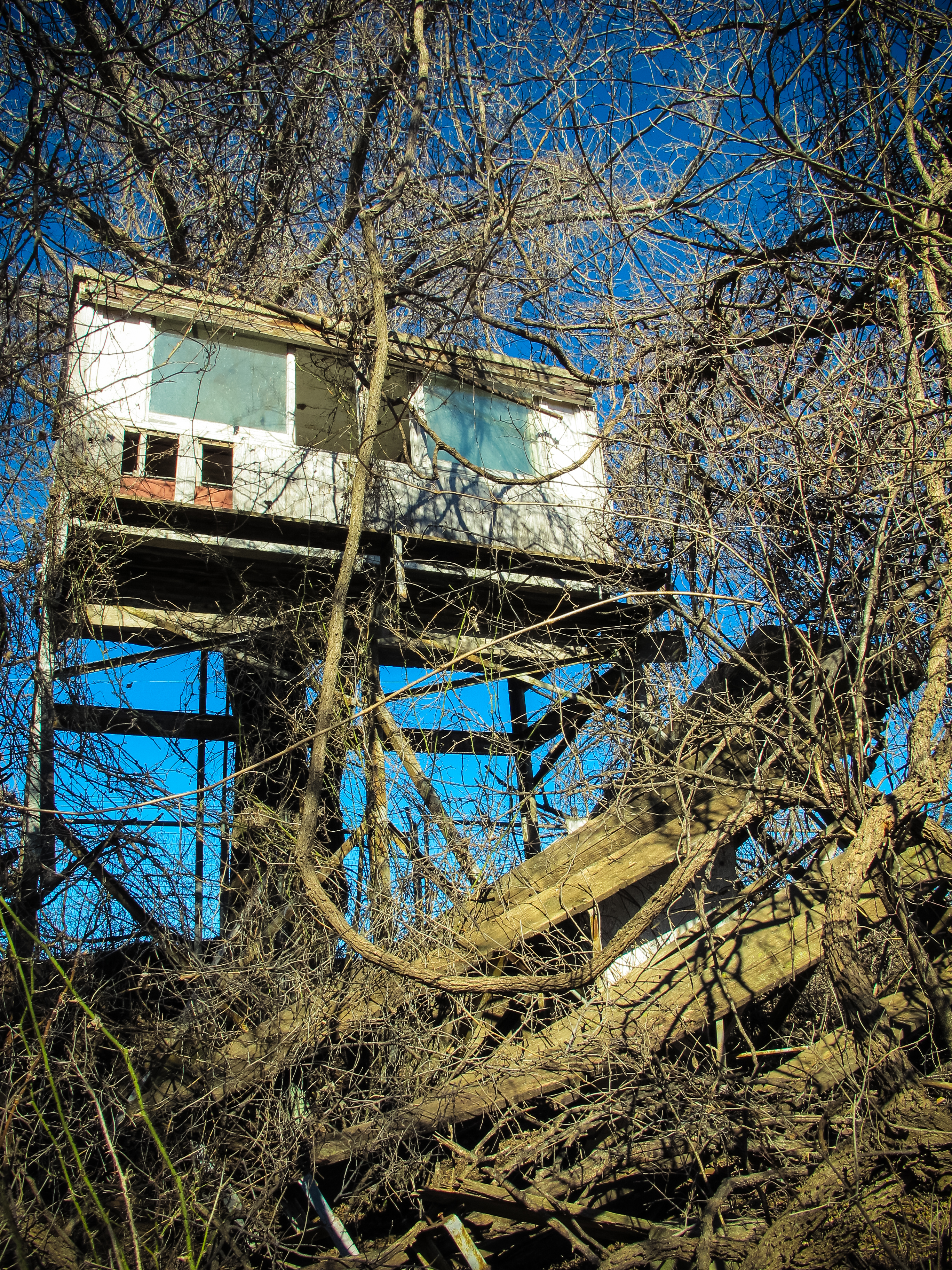 As I explored the stables and staff housing area, I discovered old bleachers to the football field. They were totally overgrown, but I was still able to navigate the brambles to get a few pictures. Even the old restrooms were standing, though it was hard to imagine an actual football field among the tall grass. When I returned to Crystal, she offered to take me back on a Kaw portion of the land to see some old barns. I gladly accepted as she told me a little more about the school’s history. Evidently, it was leased to a drug rehabilitation organization called Narconon back in the early nineties, which was a Scientologist group. During their tenure, they disallowed access from any of the tribal representatives, even resorting to armed patrols to keep their privacy. It ended up taking federal intervention to wrestle the campus back from them in 2001.
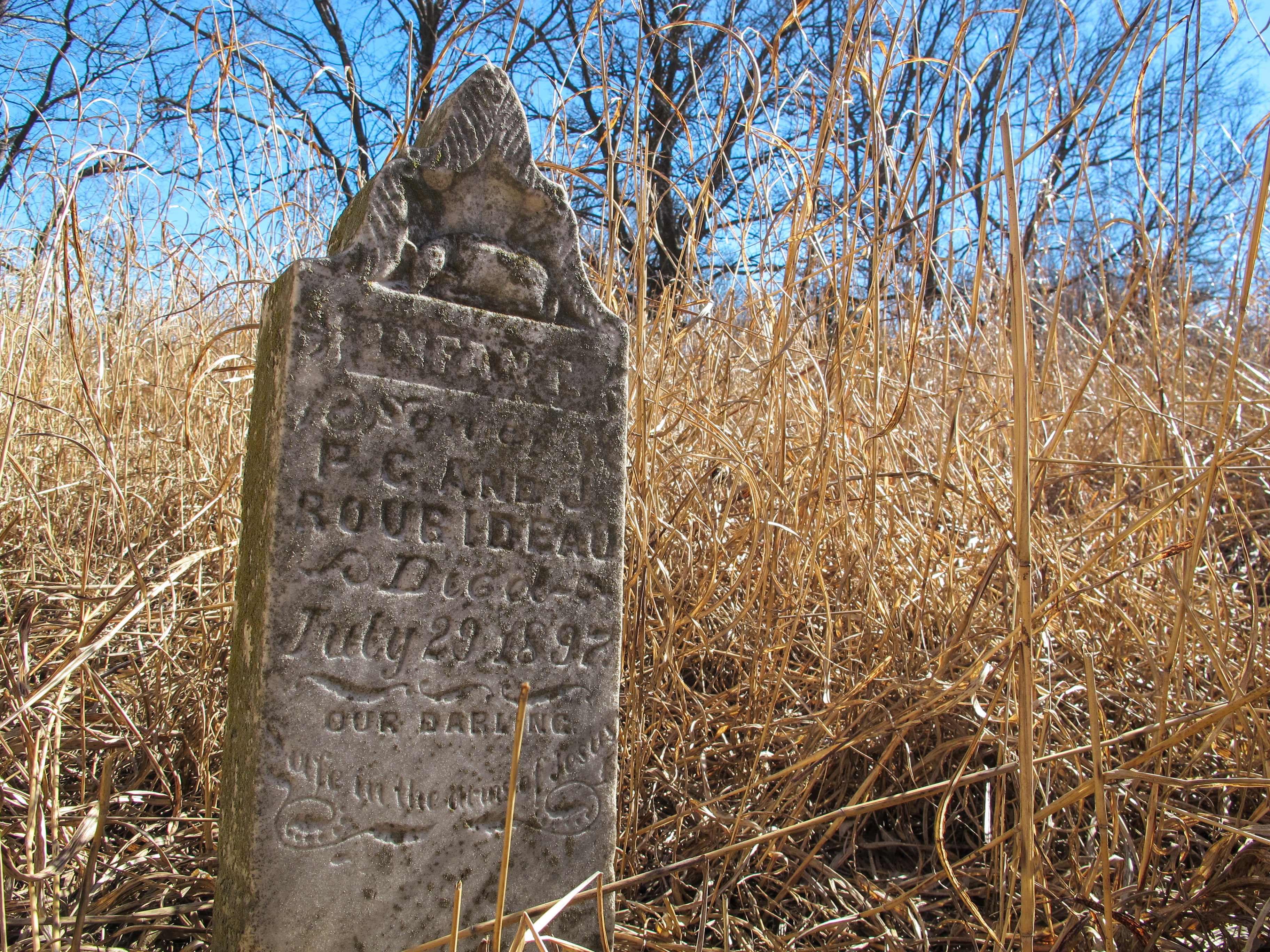 She showed me some old barns (also collapsed) and an old cemetery with grass as tall as I am. Although it’s tended during the spring and summer, it’s left alone for the winter months. I found a single grave marker among the weeds that belonged to a little girl, died in infancy in 1897. There were a number of wooden crosses resting against the fence, which were pulled up decades ago so the plot could be mowed and never replaced. Now there’s no telling where they were supposed to go.
I ended up spending about four hours wandering before my grumbling tummy and aching knees told me it was time to call it a day. I thanked Crystal for her generosity and time, promising to send some of my photos to her and the Kaw tribe. I headed home, weary and satiated. My weekend odometer read 849 miles when I pulled into the driveway this afternoon. What an amazing trip! I wouldn’t have traded the sights and sounds for anything, but I think it’s time for a little rest now.

As another Okie I love reading about the out of the way / ghost town places in the state. Someday I hope my husband and I can visit some of those places. In the mean time I’ll enjoy your visits!