
I didn’t plan on going anywhere last Tuesday. It was my day off and after having worked the weekend I was eager to sleep in. Monday night, I got home around 11:30 PM (man this new shift is still an adjustment) and crawled into bed with no thought towards the next day’s agenda. I simply drifted off to sleep, wrapped not only in a comfortable blanket but the comforting knowledge of my pending day of rest. I suppose “rest” can fit a variety of definitions, because when I awoke naturally at 8:15 the next morning, the first thing I did was use my phone to look for a potential day trip destination. It’s a reflex, I swear…and it didn’t take me long to settle on a destination.
As I’ve mentioned previously, I mark locations in my Google Maps app on my phone so that I can look at any time and see if there’s anything nearby (or in the direction I’m heading) that I’ve previously identified as interesting. The location that caught my eye that morning was an old truss bridge (surprise!) just outside of Coffeyville, KS. Not only was it a unique bridge, but my last few trips have taken me south and east; I hadn’t gone north in a while. The day promised to be a hot one, so I got ready in a hurry and left the house before 9:00.
 On my way out of the Tulsa Metro area, I drove through the city of Owasso. As you approach from the south, there is a pair of steel truss bridges whose days are numbered. The road is being widened and the old bridges are in dire need of repair; they’re being prepped for removal. I drove past, nodding in solemn acceptance. I’ve tried to stop and take pictures there a few times, but that road always has heavy traffic and EVERYONE drives 80 mph. I’ve essentially given up on capturing them in any artistic way.
 The drive to Kansas was mostly uneventful; I stopped to take pictures of a few signs along the way, but Highway 169 doesn’t have nearly as much character as a lot of the older roads I’m often turning miles on. When I arrived at my destination, I was eager to stop and spend some time there. The bridge was built in 1911, but was bypassed some time ago. The deck was completely gone and all that remained was a rusty metal skeleton, shrouded in foliage. The thing that made this bridge special was the fact that the end posts are completely vertical; most bridges of similar age and design have angled ends. It was really beautiful, but difficult to really explore; the surrounding area was quite overgrown and I didn’t fancy spending my evening removing ticks. I made a note to myself to return in the winter, when the area would be more welcoming. As it was, I was only able to capture it from the new bridge alongside.
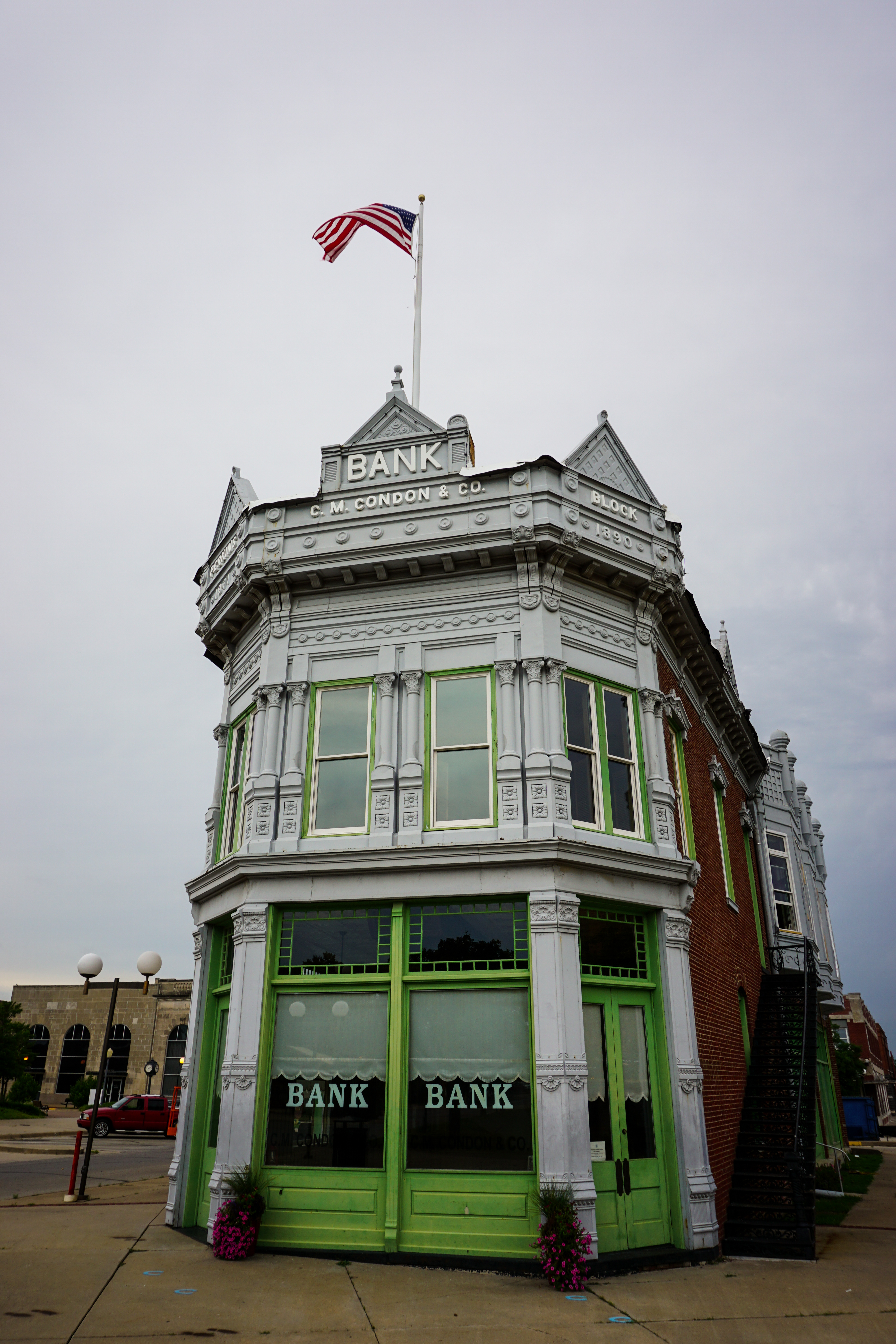 Once I was finished, I headed to downtown Coffeyville. I hadn’t been through town in well over a decade, and although I didn’t remember anything of significance I figured it wouldn’t hurt. Boy, was I blind all those years ago! Coffeyville has a WONDERFUL little downtown, complete with restored theater and late 1800s brick buildings. The old bus depot was abandoned & had a great old rusty neon sign on the corner. In fact, several of the downtown businesses had old neon signs. Closer observation revealed a sign maker, ‘Brinker Neon’, based right in Coffeyville. I rounded a corner and was suddenly face-to-face with a beautifully restored bank. Unlike most old banks I’d seen in Oklahoma, this was not a corner building made of stone; this sat by itself in a town square and had a decidedly more frontier look to it. The date on the building was 1890. As I got closer, I noticed a mural on one side with a lot of writing. I learned that in 1892, the Dalton Gang rode into town to rob that very same bank. Across the street was a little wooden sign, encouraging me to visit the old jail in ‘Historic Death Alley’. How could I resist?
 Evidently, when the Daltons rode into town that fateful October day, they hitched their horses in an alley across the street from the bank. Although they had disguised themselves, townsfolk recognized them (as they were FROM Coffeyville) and organized a response. When the gang returned to their getaway horses, a gun battle ensued. It lasted twelve minutes and eight people were killed; four gang members and four citizens. A dark event, to be sure, but the town has really highlighted it as a part of their heritage. Painted boot prints and horseshoes lead down the alley towards the old city jail. Windows are barred like jail cells, and the walls are painted with representations of brave townsfolk. There are also several painted outlines of the dead, showing you EXACTLY where the gang members fell when they perished. There were also a few memorial markers. A metal box was attached to the wall of the jail, encouraging visitors to pay 50 cents to hear the story of the Dalton Raid. I had no quarters, so I just used Wikipedia on my phone to fill in the blanks.
 When I got back to the car, it was almost 11:00; I was getting hungry. I considered going farther north, but a storm system discouraged me. Instead, I drove east towards Baxter Springs. It was a town I knew well, as it sat on Route 66. Although I’d driven through about a dozen times now, there was a small shop I’d never visited called ‘Angels on the Route’. They’ve been around for seven or eight years and are known for tasty sandwiches and frozen custard. It’s run by a lovely woman named Sue that welcomed me warmly when I arrived. Much to my delight, they still had some food left over from their breakfast service. I enjoyed some delicious biscuits and gravy while I was simultaneously engaged in conversation. A couple of working class guys were having lunch and, when I told the business owner I’d driven up from Tulsa, they took an interest. I sat and had a great gab with the whole group of them for more than half an hour, talking about my travels and the allure of Route 66. I had a lovely time there, and it was easy to see why a lot of my roadie friends make a point to stop by any time they’re driving through.
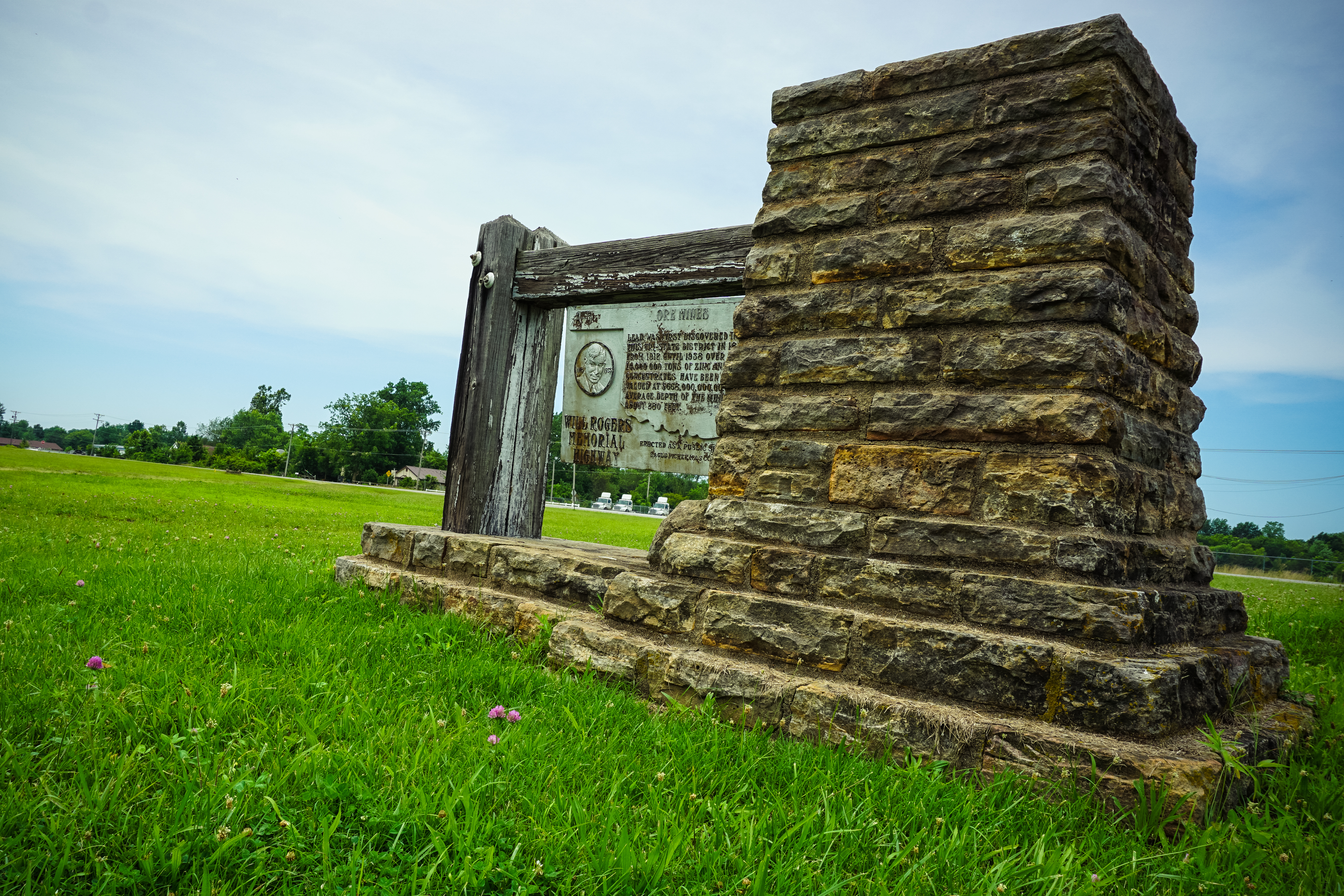 Heading south, I stayed on the Route all the way home. Not long after re-entering Oklahoma, I stopped to take a few photos of a highway marker in Commerce. Although I’d driven through many times, I had never seen the old Will Rogers Highway plaque on the north side of town. It had been placed some time in the 1950s and celebrated the mining industry of the tri-state area around commerce. What the sign didn’t know was that the same mining practices it boasted about was responsible for countless illnesses due to lead and zinc poisoning, leading to the establishment of the Tar Creek Superfund site. The nearby town of Picher was declared one of the most toxic areas in the entire country (due to poisoned water and the mountainous chat piles that now surround the ghost town) and was evacuated by the government. This old marker knows nothing about that. It just wants people to know that the millions of tons of minerals mined were valued at $668 billion dollars at the time. Well, good, I guess.
The drive south was quite familiar. I consider a lot of the roadside stops on Route 66 in NE Oklahoma my old friends. The Hole in the Wall Conoco station, Dairy King, the Coleman Theater, Sidewalk Highway…the list goes on. I stopped by Afton Station to say hi to Laurel, but it was her day off. Still, I toured the collection of classic cars and my camera got a good workout. I didn’t get back home until about 4:00 PM. The day was a mix of new and old…and it was rejuvenating. I guess that DOES qualify as rest, after all.
